
North Royalton Previous Residents Sources
The backward trail starts with one parcel and works from current data to older material. A deed identifies a legal transaction, tax and map records extend the land history, and dated listings or census schedules add household evidence when available. No one source identifies every person tied to an address. The useful result is a timeline that says what each custodian recorded, when it recorded it, and what remains uncertain.
| Source | Years It Covers | Where Held | What It Shows |
|---|---|---|---|
| Recorded documents | 1810–present | Cuyahoga Fiscal Officer, web or counter | Recorded parties, dates, instruments, and legal-description chain. |
| Tax records | 1819–1986; 1987–present online or phone | County Archives / Fiscal Officer | Ownership and valuation continuity, plus possible change clues. |
| Atlases and tax maps | Atlases 1852, 1874, 1892, 1903; tax maps 1860, 1870, 1880, 1890 | County Archives | Owner labels, roads, lots, and property geography. |
| Directory listings | Suburbs 1924–1980; criss-cross 1923, 1926, 1960–present | Cleveland Public Library | Dated address listing where the volume covers the locality. |
| Federal census | 1790–1950 released as of the research date | National Archives and library access points | Household composition and location at census time. |
| Building and BZA material | No indexed start year verified | North Royalton Building Division / city records | Project or change timing from a narrow, existing-record request. |
Start with the current parcel record, then choose the next source by the era. For a recent transfer, the recorded deed is the direct lead. For an older property, tax duplicates, maps, and the legal description often survive a changing street number better than a surname or current address. Note: Directory coverage must be checked volume by volume before treating it as a North Royalton listing.
North Royalton Parcel First
Use Cuyahoga MyPlace to select North Royalton and search by address, owner, or parcel. Record the situs address, parcel number, legal description, transfer date, and named interest holder. MyPlace exposes General Information, Transfers, Values, Land, Building Information, Building Sketch, Other Improvements, Permits, a Property Summary Report, Tax By Year, map controls, and a legal-document list lead.
| City | Optional dropdown. Select North Royalton to narrow the countywide property universe. |
|---|---|
| Search By | Required selector for Owner, Parcel, or Address. |
| Search input | Mode-dependent text field. Enter the owner, parcel, or address for the selected path. |
| View Map | Result action that opens the mapped property context. |
| Get a Document List | Result link that leads from a selected property toward recorded legal documents. |
Keep the situs and mailing addresses separate. The situs is the physical property location, while the mailing address is where county correspondence goes. Either can differ from the people who lived there. MyPlace is a public-service display, and the county says its geographic data and analytical results are not the official record. Verify a title question with the Fiscal Officer’s record or the recorded instrument.
North Royalton Previous Residents Deed Trail
The Cuyahoga Recorded Document Search is the county’s stated 1810-to-present route for recorded instruments. Use the parcel, legal description, document number, date window, and the names of parties together. The index is not a household list. It is an evidence trail for land interests, and a difficult title question needs the actual instrument and, where appropriate, professional title or legal review.
| Search Term | Optional text field for grantor, grantee, subdivision, document type, or document number. |
|---|---|
| Recorded Date | Optional From and To date fields, plus quick-range controls. |
| Search scope | Choose Index Only or Index & Full Text (OCR). Multiword handling differs by scope. |
| Quick or Advanced | Landing-page modes for a focused party, document, date, or legal-description search. |
| Parcel format | Use dashes in the Recorder’s parcel pattern, unlike the city GIS parcel entry. |
- Start with MyPlace and copy the parcel number, transfer lead, legal description, and named interest holder.
- Find the acquisition deed or recorded instrument using the party, date, document number, parcel, or legal-description evidence.
- Read the instrument and identify the seller or grantor named in that transaction.
- Search that earlier party as a grantee to locate the prior acquisition, then repeat the sequence.
- When a web result fails, use the Recorder counter and the appointment-only County Archives property-research route with the parcel and source notes.
- Grantor
- The party transferring an interest in the recorded instrument.
- Grantee
- The party receiving that interest. Searching the same person in both roles helps move through earlier transactions.
- Chain of title
- The documented sequence of recorded interests in a property, not a statement about everyone who lived there.
- Legal description
- The subdivision, lot, block, metes, or other land identifier used in recorded documents. It can remain usable when an address changes.
Note: Search results identify recorded leads; read the actual instrument before describing its legal effect or a property’s recorded history.
North Royalton Past Legal Descriptions
A street number can fail in older research because documents may rely on a subdivision, lot, section, road, parcel, or map location. The legal description bridges those versions. In the Recorder search, a parcel is entered with dashes, while the North Royalton Community GIS accepts a parcel number without dashes. Record both formats exactly as used by their respective tools.
Handwritten records, OCR errors, trustees, estates, corporate names, changing descriptions, and name variants can interrupt a direct search. Keep the book or page, document number, map year, parcel variant, source, and uncertainty together. The next step is a documented conflict, not an assumed straight line.
North Royalton Past Resident Maps
County Archives holds a deeper property timeline than a modern portal. Its tax records run from 1819 through 1986, while the Fiscal Officer provides the 1987-to-present tax route online or by phone. County atlases for 1852, 1874, 1892, and 1903, plus suburban tax maps for 1860, 1870, 1880, and 1890, can supply owner labels and property geography. Original map volumes are described as roughly 1860 to 1945, with later map material in the Fiscal Office Map Room.
Bring the parcel number, a current or older street form, and the legal description to an Archives appointment. Compare maps with tax duplicates and appraisal material rather than reading a building outline as a complete property history. The research notes that an outline can show a structure stood on the property in that map year, while changing tax values can suggest a period to investigate further.
Note: A map date shows a mapped condition for that year, not an exact construction date or a complete household.
Royalton Address Names
Royalton Township was renamed North Royalton in 1881. A historic catalog, map, directory, cemetery reference, or tax record may therefore sit under either name. This is the main demonstrated continuity trap for past-resident research. Search Royalton and North Royalton, preserve an older road or locality description, and return to the legal description when a modern address has no useful match.
No verified citywide street-renumbering date, address-reassignment project, or local records-loss event was found in the research. Avoid treating a missing modern number as proof that a property did not exist. County Archives specifically cautions that dimensions, street names, and property descriptions can change.
North Royalton Previous Residents Listings
Deeds identify recorded land interests, not everyone who lived at the address. For the household layer, use the documented Cleveland-suburb directories, criss-cross directories, and released census together. The directory groups are available only for their stated library scope, so confirm that a North Royalton street or municipality appears in the actual volume. For collection details and access channels, use the North Royalton city directory collections.
Pair records in order: address or legal description → dated directory or criss-cross entry → released census → map, tax, deed, death, or probate evidence. The 1950 census is the most recent open decennial census in the research. A name found in one source may be a listed subscriber, an owner, a relative, or another documented party. Only the source itself establishes its role.
- Choose a directory edition close to the transfer or map year and copy the address, name, page, and abbreviation key.
- Check the next available edition on either side, including Royalton as a catalog term for older material.
- Locate the matching released census record when an address or locality can be tied to the household.
- Test the household sequence against the deed, tax, map, death, or estate trail and keep conflicting dates visible.
Lawful use. North Royalton address history supports family history, estate research, and personal property curiosity. Do not use a historical record to stalk, harass, or track a living person.
North Royalton Previous Residents City Files
Building, planning, and Board of Zoning Appeals material can date construction or a recorded change at an address. The Building Division’s forms indicate that an application can contain a property address, parcel, owner or prospective buyer, applicant, project details, plans, and contacts. No public historical address-result portal was verified. The documented route is a narrow request to the Building Division or the city public-record process, naming the address, approximate date range, and existing record series.
The city’s policy permits a request without special wording, a written form, identity, or a stated purpose. It requires prompt inspection during regular hours and reasonable copy timing subject to volume, storage, review, and redaction. The city need not create a new list or analysis. Building files are therefore a change-timing source, not a substitute for a historic household roster. Certificate applications and occupancy records have a city-code access limitation tied to a narrowly defined interest in the property.
North Royalton Previous Residents Endpoints
When the address trail reaches a death, marriage, or estate event, follow the custodian for that record type. Cuyahoga Probate handles estates and marriage records, while the Ohio Department of Health is the stated certified birth and death route for North Royalton events. The County Archives also holds historical vital, marriage, probate, naturalization, and estate series. Ohio History Connection’s historical death resource can supply a statewide lead when the event was registered elsewhere in Ohio.
Ohio’s certified vital-record fee rule is shown in this state record image.
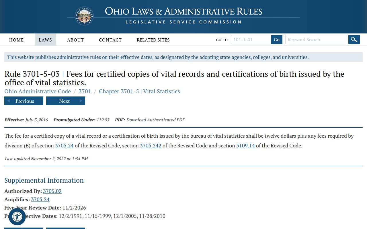
The rule is an access reference for a certified-record request, not proof that a named person lived at an address.
Ohio’s vital-record issuance law states the signed-application and fee framework, subject to named confidentiality provisions.
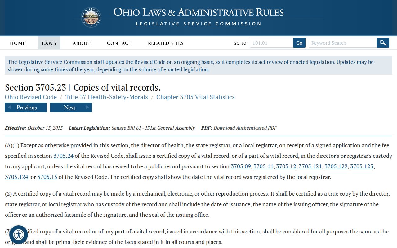
Use a vital, probate, cemetery, or obituary record to close or qualify a dated trail, then preserve the source and date rather than inferring continued occupancy.
Note: A death, marriage, or estate event can set a date boundary without proving that a person remained at the address.
North Royalton Past Resident Limits
A public property card can show a recorded interest holder, but it does not establish a complete household. A mailing address may differ from the property’s situs address, and an address listing can omit adults or use a subscriber name. Building and court materials have their own purpose and access limits. Treat each result as evidence of a specific relationship or event, not a complete personal profile.
For a hard case, use the County Archives appointment form and select the relevant topics, such as City Directory, Building Card, Estate Case File, Maps, Property Records, or Tax Records. Give staff the North Royalton address, old parcel number, historic street spelling, owner name, expected date range, and any document or map lead. The Archives supports in-person, email, and mail research, so an online dead end is not the end of the record trail.
Note: Keep all source dates and unresolved differences in the research log so later records can revise the address history without obscuring the earlier evidence.